The US Dept of Labor does not publish a consumer price index specifically for refrigerators, but the category it belongs in showed essentially zero nominal inflation between 1994 and 2018. The real price decline shown in the first chart probably continued through 2018.
Refrigerators and appliance prices spiked by more than 10% in 2021 as consumer demand for durable goods grew 20% during the pandemic, supported by government transfer payments.
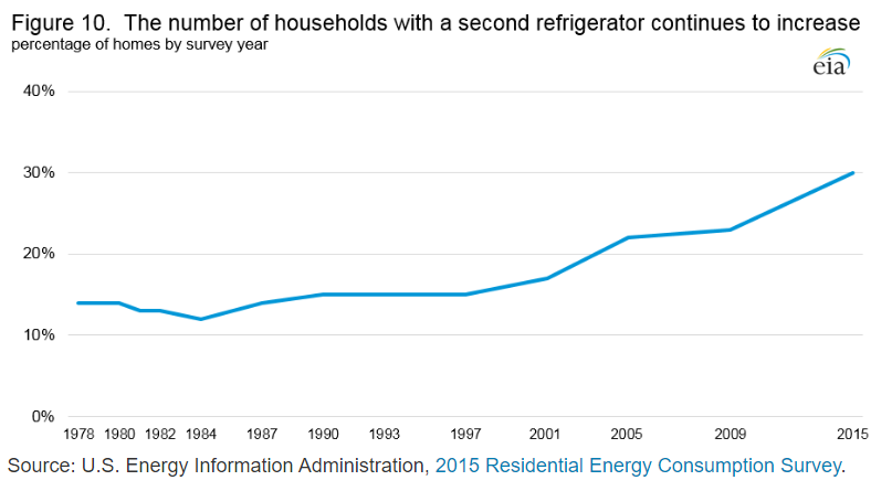
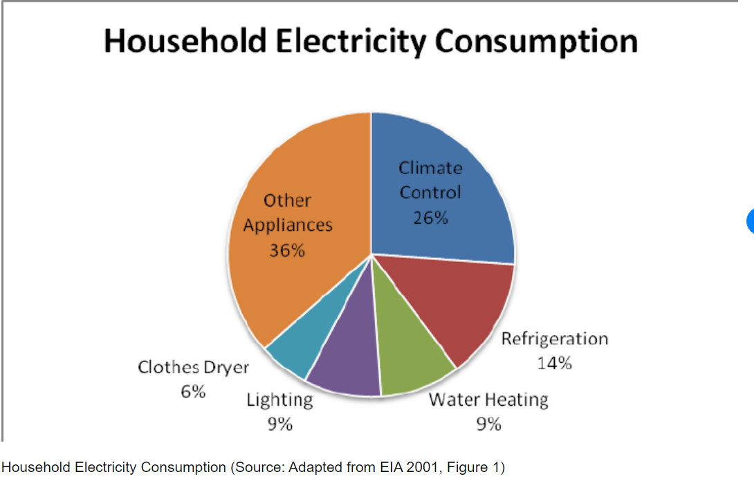
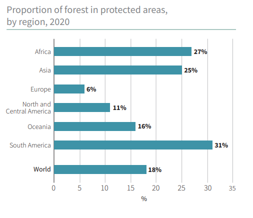
Refrigerators now account for just 7% of home electricity consumption, down from 14% in 2001.
Opinion writers differ on who gets credit for the improved price/performance results for refrigerators, but it seems clear that both energy standards and inventive firms share credit.
“Many challenges are associated with drought, wildfire, invasive species, and outbreaks of insects and disease—all made worse by climate change. Warming temperatures mean more energy in the atmosphere, which is consistent with severe weather events, such as floods, tornadoes, blizzards, ice storms, and hurricanes.”
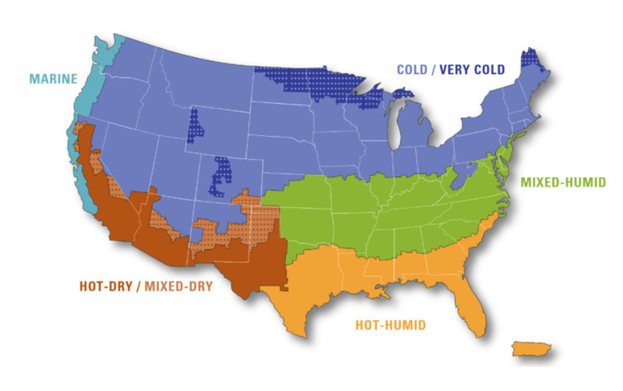
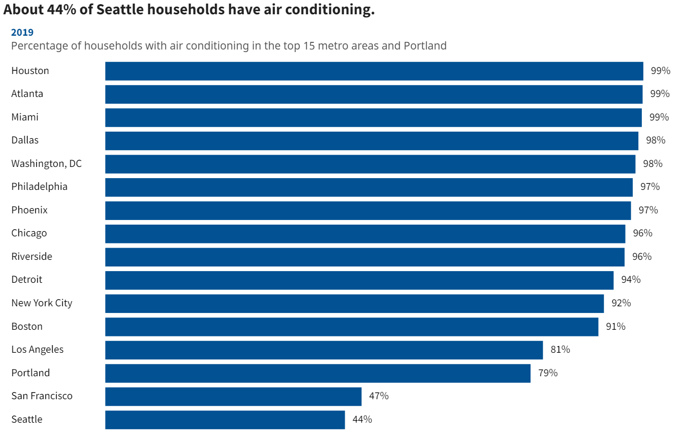
Air conditioning demand varies significantly by region/climate. AC use increased from 75-99% in the South, from 60-90% in the Midwest, from 50-85% in the northeast and from 40-60% in the West. AC demand varies based on peak temperatures, the number of days at peak temperature, the number of hours per day at peak temperature and the humidity (felt temperature). San Francisco, Portland and Seattle rarely “require” AC, even though their residents could afford this service.
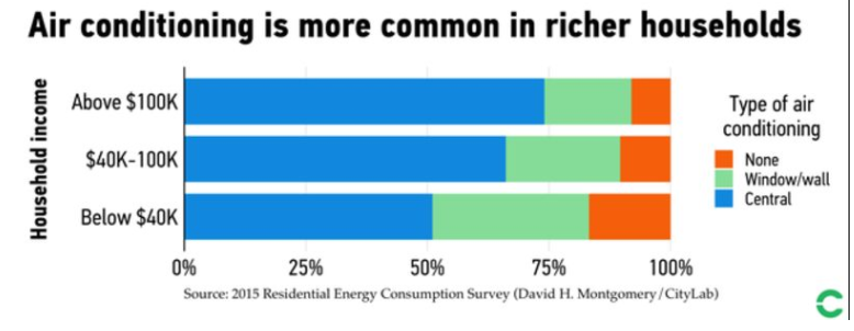
The US, Japan and Korea lead the world in households with air conditioning. China and Saudi Arabia are representative of moderate-income nations with relatively high AC usage. Most other nations, including the wealthier European nations, remain at very low rates of AC adoption (10%). This is a “good news” item for personal comfort, but not so good for energy consumption.
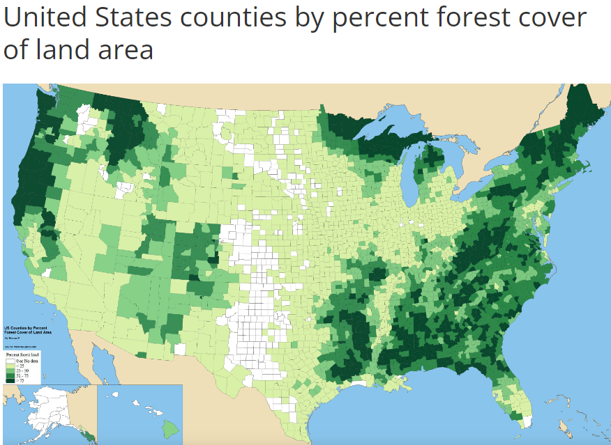
I hiked in each of the 200 counties within 3 hours (210 miles) of Indianapolis during 2020-2021. I’d like to share hikes in 10 of the 60 counties within 110 miles of Indy.
Morgan-Monroe State Forest
Morgan-Monroe State Forest offers a variety of moderately challenging woods and stream valley hikes just an hour southwest of Indy. You might combine this with a hike in Yellowwood State Forest just 30 miles further south.
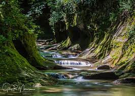
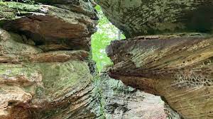
Portland Arch Nature Preserve is less than 90 minutes NW of Indy via I-74 and US 41 near the Illinois border. It features deep stream valleys, cliffs and a small “arch” with a stream running through it. Combine this hike with a visit to 90 foot high Williamsport Falls just 8 miles to the north or Shades State Park 35 miles to the south.
McCloud Nature Park is 40 miles WNW of Indy. Trails follow the hills and valley of Big Walnut Creek. Combine this with a hike in Big Walnut Nature Preserve 8 miles west, Sugar Creek Nature Park 30 miles NW or Fern Cliff Nature Preserve 30 miles SW.
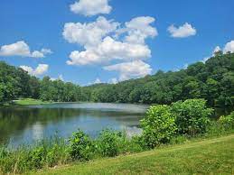
Spring Mill State Park is 90 miles south of Indy, past Bloomington and Bedford via IN-37. This is limestone country. The park features history, steep valleys, hills, forests, lakes and an inn. Combine this with a stop at Cedar Bluffs Nature Preserve 30 miles north or Hardin Ridge Recreation Area on Lake Monroe 30 miles north.
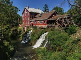
Clifty Falls State Park is 90 miles SE of Indy. It features several trails that view waterfalls or rapidly flowing streams that are moving from the standard elevation of SE Indiana down to the Ohio River. Combine this hike with a visit to Madison, IN or Versailles State Park 30 miles north.
Calli Nature Preserve is located 70 miles southeast of Indianapolis along the Muscatatuck River. The short trail explores a small stream valley and the river valley. It is best visited when Spring wildflowers are in bloom. Combine this hike with a visit to Selmier State Forest just 5 miles north or Muscatatuck National Wildlife Refuge 12 miles to the west.
Versailles State Park is located 75 miles southeast of Indianapolis. The park features a lake and trails that follow streams/historic roads upland to the east. Combine this hike with a stop at Calli Nature Preserve or Selmier State Forest 20 miles to the west.
France Park is located 80 miles north of Indy in the Wabash River Valley. The park features a lake in an old quarry, overlooks, waterfall, a beach and some geological history. Combine this hike with a stop on the Nickel Plate Rail Trail between Peru and Kokomo 25 miles east.
Ouabache State Park is located 110 miles northeast of Indy, south of Ft. Wayne, about 30 miles from the start of the Wabash River in Ohio. This is still relatively flat, agricultural Indiana, but the park features pines forests, wetlands, a small lake and a herd of bison. Combine this hike with a stop at the JE Roush Fish and Wildlife Area 25 miles to the NW or the Loblolly Marsh 16 miles south.
Kickapoo State Recreation Area is 100 miles NW of Indy, just across the Illinois border. It features trails along the Versailles River in an area that was once only strip mines. Combine this with a visit to the Forest Glen Preserve 20 miles to the south or the Portland Arch 30 miles to the east.
I hiked in 200 counties within a 210 mile radius of Indy in 2020-2021. These 10 are my favorites in the roughly 2 hour driving range (110-160 miles) out of 70 counties visited.
Allerton Park is located 15 miles west of Champaign, IL. The formal gardens are the highlight. Typical central Illinois woods and streams trails are also on the property. Combine this with the Lake of the Woods Forest Preserve and Mabery Gelvin Botanical Gardens in Mahomet, just NW of Champaign.
The Patoka Lake area includes 26,000 acres south of French Lick and east of Jasper, IN. The 6 mile main trail hike to Totem Rock is one highlight in this heavily wooded and rugged part of southern Indiana. The trip down IN-37 from Bloomington to Bedford to Paoli is quite scenic. Then, the fun begins in the most scenic part of the state SW to Patoka Lake. Combine this hike with the Pioneer Mothers Memorial Forest in Paoli.
The Pumpkinvine Trail stretches for 25 miles, connecting the scenic and historic small communities of Goshen, Middlebury and Shipshewana. The trail cuts through these towns and across scenic farming areas. This is Amish Country, east of Elkhart, IN. Combine this with a visit to Chain o Lakes State Park (east) or Potato Creek State Park (west).
Gabis Arboretum is located just west of Valparaiso, IN. The arboretum is built around a small lake and stream. A hiking trail covers this area, a small prairie and a pine woods. The site also contains an outdoor model train with complementary plantings. Indiana Dunes is 20 miles to the north.
Pokagon State Park is in the glaciated “kettle” lakes region of NE Indiana. Hiking trails cover the lake shore, wetlands, streams and small hills. Combine this with a trip to Douglas Woods Nature Preserve 20 miles to the south or Chain o Lakes State Park 45 miles to the SW.
Jackson-Washington State Forest is located just west of Seymour, IN. It doesn’t get the attention or traffic of Brown County to the northwest or the Hoosier National Forest to the southwest, but it provides the same back woods scenery and changes of elevation found on the Knobstone Trail to the south!
Bernheim Arboretum and Forest is located 25 miles south of Louisville. You’ll see the hills start to grow as you pass the Louisville airport on I-65. This park displays a variety of trees and offers hiking trails around lakes and hills. It also displays “the Giants”, a family of woodland creatures found only here. This is bourbon country, Jim Beam is across the street. Combine this hike with a visit to Yew Dell Botanical Gardens east of Louisville or the Falls of the Ohio State Park in Jeffersonville, OH.
Pyramid Hill Sculpture Park is located 25 miles north of Cincinnati in Hamilton, OH. Hike the roads and trails to visit hundreds of outdoor sculptures. This is a hilly area, so the hiking is good. Combine this with a visit to Mt Airy Park and the Cincinnati Zoo or Twin Creek Park 25 miles NE or Hueston Woods State Park 20 miles to the NW.
Visit John Bryan State Park and Clifton Gorge State Nature Preserve along the scenic Little Miami River 25 miles east of Dayton. The water cuts a true “gorge” through the landscape, quite unexpected in this relatively flat area of central Ohio. Visit Wright-Patterson AFB 14 miles to the west or Charleston Falls 30 miles to the WNW.
Charleston Falls Preserve is located just 15 miles north of Dayton and east of its airport. The falls is suprisingly large. The stream and woods trails are enjoyable. Pair this with Clifton Gorge or nearby Taylorsville Metro Park.


